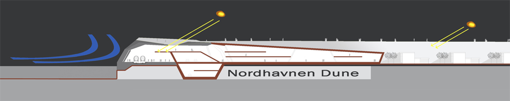
action 1: Nordhavnen Dune
Re- establishing the identity of a coastal landscape in the area, but looking to the original morphology of the maritime shores as an innovative instrument for a bioclimatic, environmental-friendly settlement and sustainable mobility.
In the project proposal, action 1 is supported by a built-up coastal element called Nordhavnen Dune, an innovative instrument for a bioclimatic, environmental-friendly settlement and for sustainable mobility.
-
The Nordhavnen Dune consists in a linear built-up sandy relief, perimetrically running around the area, open to the south and to the existing town, proposed in height, width and section in order to work as climate-mitigator, protecting against the dominant east and north-east winds, increasing the effects of the solar radiation at the ground level, tempering the local humidity, and generally improving the bioclimatic qualities of the new settlement .
- The Nordhavnen Dune reports the memory of the original sandy landscape on the natural shores of the maritime lowlands of northern Europe.
- The Nordhavnen Dune is dimensioned in order to host in its subsoil the light railway ring (main public mobility element of the project) and connected public open spaces, together with a local vehicular ring road and with the general amount of parking areas for both temporary and residential uses of the new settlement. Where the Dune has been interrupted, the railway and the vehicular ring are running through a cutting with wooden strings on both sides.
- The Nordhavnen Dune is organized on its surface in order to create a circuit of public spaces, pedestrian and bicycle paths connecting the existing town with the harbour front and with the old fishermen's village of Fiskerihavnen, and offering along some outstanding view points on the cityscape of the new settlement.
- The Nordhavnen Dune is running adjacent to all different sectors of the settlement and to most of the existing industrial buildings to be maintained, at the same time connecting or separating building and activities, in order to harmonize their requirements.
action 2: Harbour Mile
Unifying the entire sequence of the southern harbour waterfront as a vibrant and dynamic place of centrality, by means of an integrated system of directional buildings and sheltered public open spaces.
This integrated urban architecture has been named Harbour Mile, referring to the proposed sequence of central public spaces, hosted into green houses open to the waterfront in the summer, served by the light tramway line and connected to the inland by a transversal system of multifunctional buildings (horizontal towers) dedicated to directional, culture, art, knowledge and research, leisure, entertainment, commerce and community facilities.
- The sequence of green houses of the Harbour Mile and the immediately surrounding open areas represent more than the 40% amount of proposed public urban spaces, being a further 20% contained as indoor pubic space into the multifunctional horizontal towers. The sequence of the Harbour Mile includes the future cruise terminal. The continuity of the sequence across the harbour basins of the area (including the basins still open for navigation) is provided by pedestrian revolving bridges.
- Each green house is a two storey hall with frequent connections between the two levels. The light railway ring line is directly connected to the lower level of the hall, furnished with facilities such as info points, shops, cafes. The Harbour Mile side of the horizontal towers approaching the green houses is directly a part of the hall, mostly opened to the public space.
- The architectonical identity of the green houses is oriented on the light, transparent idea of a crystal building, able to assure a strong sense of sociality also in the winter climate without loosing a direct visual connection with the outside.
- In order to assure the sustainability of the green houses, their envelopes are intended to be studied as a complex system of glass panels and wooden screens, due to be opened and oriented after a microclimatic indoor and outdoor control
- The green houses are furnished by indoor vegetation and named by the proposed essences, inspired to the gardens of southern countries.
- The Harbour Mile is fully accessible by light railway through 3 different stations . Private vehicular access to Harbour Mile is discouraged. Nevertheless a restricted number of parking places is provided under the Dune adjacent to the light railway stations. Vehicular transports to the Mile is admitted along the vehicular ring under the Dune.
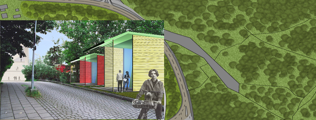
action 3: Contemporary Habitat
Offering a new contemporary habitat with experimental low-rise family housing, multi-storey buildings for assembled dwellings, common open spaces and local services, including floating houses, off-shore wind&solar units for zero-energy housing strings, multifunctional typologies, leisure indoor and outdoor sport facilities, horticultural areas.
- All low-rise family housing typologies of the contemporary habitat are intended to promote innovative relations between working and living, including forms of job sharing, home- and e-working. The low rise family typologies proposed in the project are 6, different for size and composition, including a typology of floating house to be used on the water of the dismissed harbour basins. All typologies are flexible for additional work and living spaces and fully compatible to be assembled, producing a large set of different combination.
- Density, scale and urban fabric of the low-rise housing sectors in the contemporary habitat are referring to the fishermen's village of fiskerihavnen. The old village is fully integrated into the new settlement.
- The urban fabric of the contemporary habitat is proposed in height, width and section in order to maximise the winter solar radiation at the ground floor.
- Some low-rise sectors are assembled in experimental zero-energy housing strings, adjacent to the dismissed harbour basins, furnished of off-shore wind & solar plant units.
- The peculiarity of the multi-storey buildings for assembled dwellings is the semi-public space included at each level, intended as an external addition to the dwellings in order to encourage social life. The multi-storey dwelling typologies proposed in the project are 4, with a large possibility of different combination and flexibility depending on the social assets of the incoming population.
- The multifunctional typologies are intended as activity-containers including public, semi-private and private spaces, able to adapt them to a strong flexibility, due to the quick evolution of the spaces for knowledge-oriented jobs and research, for e-commerce, leisure and entertainment, for art expression and culture.
The project propose 8 different multifunctional typologies including the horizontal towers of the Harbour Mile, while the location is depending on the general asset of the settlement:
- Type A. 50% directional, knowledge, research) /30% commercial//20% indoor public space
- Type B. 40% directional/40% art & culture/ 10% leisure10% indoor public space
- Type C. 60% commercial/10% entertainment/ 10% indoor public space
- Type D. 80% entertainment/ 20% indoor public space
- Type E. 80% art & culture/ 20% indoor public space
- Type F1. 50% community facilities/20% commercial/ 10% art&culture/20% indoor public space
- Type F2. 50% community facilities/30%commecial/20% indoor public space
- Type G. 80% officies / 20% indoor public space
The local mobility in the Contemporary Habitat is restricted to pedestrian and bicycle paths in the housing sectors. Access to single houses is exceptionally admitted and suitable on pedestrian paths for light transport vehicles in case of residents transports. The local public transport net includes a circular vicinity service running by electric busses on dedicated lanes and directed to the stations of the light railway ring. Adjacent to light railway stations in the Dune subsoil, a number of permanent parking places is provided for residents. Private vehicular access to horizontal towers is discouraged. Nevertheless a restricted number of parking places is provided under the Dune adjacent to the light railway stations. Vehicular transports to the horizontal towers is daily admitted along the vehicular ring under the Dune.
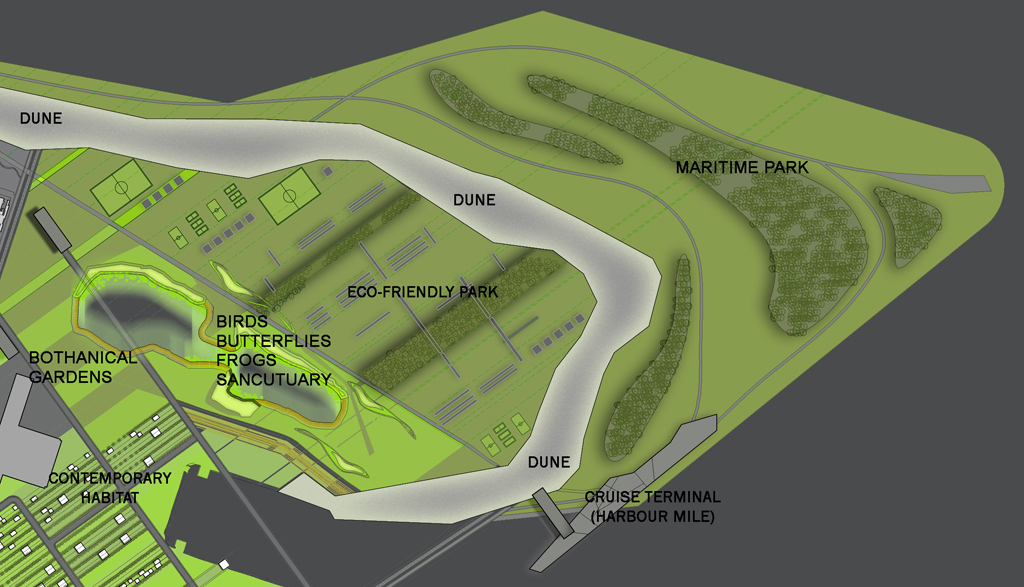
action 4: Eco-friendly Park
Integrating landscape and architecture, in an asset of elements, eloquent for a eco-friendly urban culture and style of life: the Eco-friendly Park
- The Eco-friendly Park of Nordhaven is extended in the north-east end of the new settlement, including the existing ponds area and the grounds reclaimed by filling in earth.
- The Park is divided in an outer area (Maritime Park), exposed to the north-eastern maritime winds, planted as a forest, and an inner area (Inner Park), sheltered by the Dune, hosting grounds for horticulture, greeneries, a botanical garden and a zoological sanctuary.
-
- The planting of the Maritime Park is organized into a meander layout composed by outer belts of slow growing local essences (60% Birch and 40% Rowan) and inner belts of fast growing local essences (70%Willow and 30% Poplar). The planting of the different essences and the general design is phased in order to obtain a landscape quality of the area along the whole growth period of the trees.
- The Dune natural sandy surface is planted of maritime bush. It is crossed by a net of transversal pedestrian walkways, in order to connect the park on both sides. The top of the Dune hosts a linear photovoltaic and wind plant.
Project team: Roberto A. Cherubini, Sara D'Innocenzo, Anna Esposito, Andrea Lanna, Antonio Menghini Calderon
Collaboratori: Alessandro Fabiani, Anteo Ismaili, Stefan Mrdak